The Cabot Trail – Cape Breton, Nova Scotia
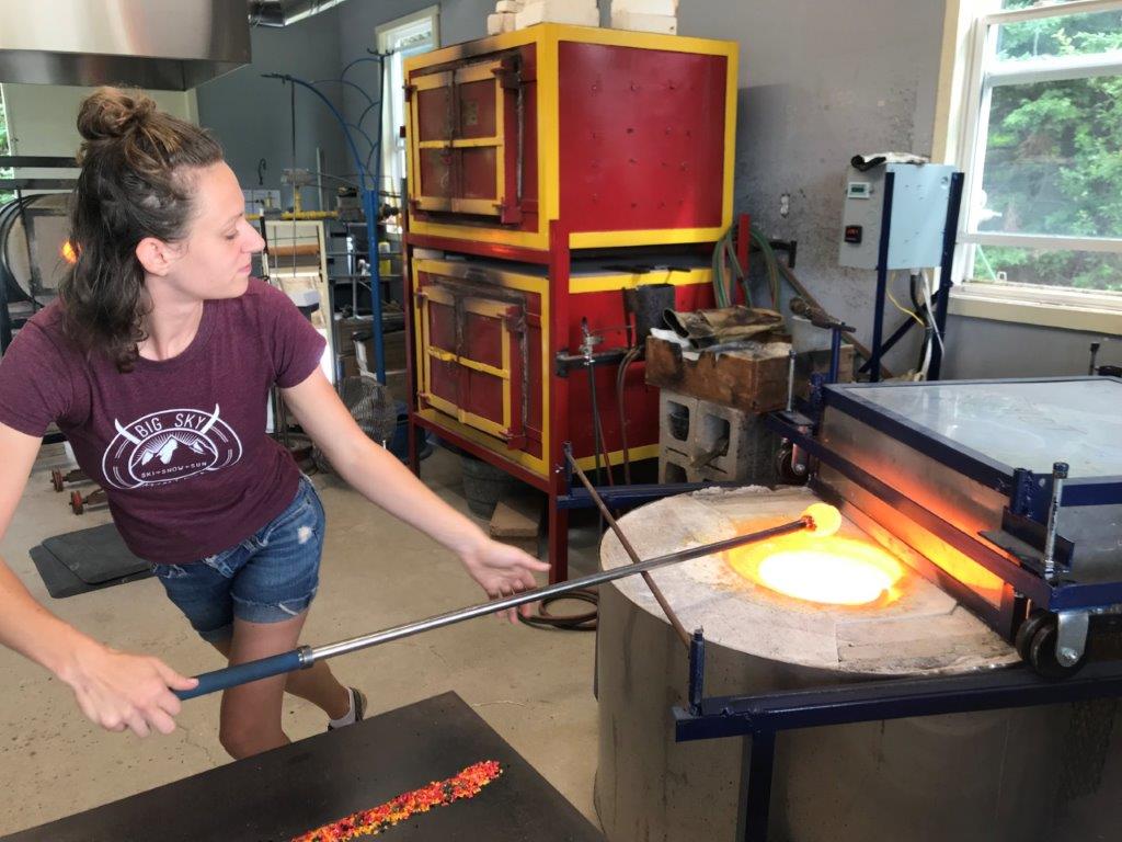
2. Melt glass
Travelling the Cabot Trail….and reaching the northern “White Point”…
The Cabot Trail is a 198km scenic roadway encircling Cape Breton Island in Nova Scotia, passing forests and rugged coastline. It is named after the explorer John Cabot who landed in Atlantic Canada in 1497. The northern section of the Cabot Trail passes through Cape Breton Highlands National Park. The western and eastern sections follow the rugged coastline, with views of the ocean. The southwestern section passes through the Margaree River valley before passing along Bras d’Or Lake.
Following our visit to the Alexander Graham Bell Museum on our first day on Cape Breton, we decided to do an out and back trip of the western part of the trail which was passed our accommodation. The first section, as we travelled towards the coast, was largely forested with a spattering of various houses and business along the way. As we hit Margaree Harbour on the coast, the whole look changed. We were surrounded by green fields that almost fell into the sea. They were interspersed by randomly placed picturesque houses in white and other colours.

We were aiming for Cheticamp, a traditional Acadian fishing village situated along the picturesque Cabot Trail, nestled between the majestic highlands and the waters of the Gulf of St. Lawrence.
(The Acadians are the descendants of French colonists who settled in Acadia during the 17th and 18th centuries, some of whom are also descended from the Indigenous peoples of the region. The colony was located in what is now Eastern Canada’s Maritime provinces (Nova Scotia, New Brunswick, and Prince Edward Island), as well as part of Quebec, and present-day Maine to the Kennebec River. Although today most of the Acadians and Québécois are French-speaking (francophone) Canadians, Acadia was a distinctly separate colony of New France. It was geographically and administratively separate from the French colony of Canada (modern-day Quebec). As a result, the Acadians and Québécois developed two distinct histories and cultures. They also developed a slightly different French language.) https://en.wikipedia.org/wiki/Acadians
In New Brunswick, Quebec and other parts of Nova Scotia, the houses of the Acadians were marked with a large cross on the front. These crosses were largely missing on Cape Breton, although the French flag could be seen flying alongside the Canadian flag in a lot of instances.
Artworks….
In addition to the lovely walking trails in the area, the Cabot Trail is also home to numerous artists. We visited a handful of galleries during our time there, although have very few photos as naturally artists do not like photos to be taken for copyright purposes. We did visit a studio where glass artisans show their work, and were fortunate to watch Lex at work, blowing a bowl.


Walking….
On the second day of our time in Baddeck, we woke to misty weather and by the time we set off on our loop of the Cabot Trail, it was raining. This time we were starting on the eastern shore and planning to go all the way around, ultimately repeating the section that we’d done to Cheticamp the day before. We also hoped to walk at least one trail along the way, particularly the famous Skyline Trail which overlooks the Gulf of St. Lawrence, known for migratory whales.

By the time we reached Ingonish and the nearby Middle Head Trail, the rain had cleared although it was very windy. Armed with our rain jackets – just in case – we headed off on the 4km loop of the headland. Unfortunately we didn’t get to take photos of either of us on the red chairs at the end point of the walk as another group was hogging them (see “Tribute to the Red Chair” for more info). But we did make it back to the car before it rained.

After a brief coffee stop, we continued further north, aiming for our most northern stop at White Point. Not sure whether it’s the position on the North Atlantic or just due to the weather on the day, but we were forced to sit in our car protected from the howling winds, watching the tumultuous waves as we munched on our pre-prepared sandwiches.

As we drove through the Highlands, the weather cleared to mostly blue skies and sunshine. So by the time we reached the other side of the National Park and the Skyline Trail, we were ready for another walk. This time it was on a very wide, well-used path ending with a long downhill boardwalk. Sadly, as we reached the end of the trail, the mist and rain started coming in and we only just managed a few photos before the view was totally gone. Walter was prepared for the heavy rain as we walked back to the car as he’d taken a rain jacket. Glenda had decided not to take hers so was pretty wet by the time we arrived back .





 Book Cover Reveal
  Sneak Preview
  Prague – Winter Wonderland
  Porto Venere – gateway to the Cinque Terre
  Lucca Comics & Games 2023
  Orvieto – 6 years later